Wildfire command, hour by hour: the record the federal incident feed overwrites
An hourly record of the command level on US wildfires since July 3, 2026, linked to carbon project boundaries, and a first look at whether a fire's command level adds anything to what satellites already show about how large a fire will grow.
Why this paper
In 2026, thirteen wildfires tracked by The Ember Report, a morning briefing for contractors and government cooperators who supply wildfire operations, burned into nine forest carbon offset projects. Fire agencies rate the command on each fire, its command level, from Type 5, the lowest, to Type 1, the highest. Lower numbers mean more complex fires. This paper examines whether command level helps predict how large a fire grows and, therefore, the risk to a carbon project.
The federal incident feed, the public list of fires published by the National Interagency Fire Center (NIFC), shows only each fire's current command level. We have kept each fire's command level, recorded every hour, since Jul 3, 2026, in what we call our command record. This paper shows what the command record holds, and what one season can and cannot tell you about command level as a leading indicator for fire growth.
We wrote this report for people who rate, insure, study, or manage carbon projects.
1 · What the federal feed overwrites
This season, three wildfires burned deep into two forest carbon projects:
- Kaiser Canyon (Washington) burned about 138,000 acres, including 32,788 acres (7.2%) of the Colville Forest Carbon Project.
- Modrite (Washington) burned 25,554 acres (5.6%) of the same Colville project.
- Box Springs (Oregon) burned into the Opal Mountain carbon project, then merged with a larger neighboring fire, Crosswhite. Together they burned 12,172 acres (86.4%) of the project.
Background: A Type 3 command is run by a Type 3 team or a single incident commander; for simplicity, we count both as Type 3 command. We group Type 1 and Type 2 as one level, Type 1/2 command, run by a Complex Incident Management Team (CIMT). CIMTs are interagency, and some are sponsored by a state, such as the Oregon Department of Forestry's teams, among many others. Kaiser Canyon and Box Springs were each under Type 1/2 command by Jul 19, and Modrite's Type 1/2 team took command on Jul 21.
Today the federal incident feed lists Kaiser Canyon as a Type 5 incident. Modrite shows as a Type 5, and Crosswhite shows as a Type 3. The federal incident feed no longer lists Box Springs, which merged into the Crosswhite fire.
Table 1. What the federal incident feed shows now
| Fire | Under Type 1/2 command from | What the feed shows today |
|---|---|---|
| Kaiser Canyon | Jul 19 | Type 5 |
| Modrite | Jul 21 | Type 5 |
| Box Springs | Jul 19 | No longer listed (merged into Crosswhite) |
| Crosswhite | — | Type 3 |
Crosswhite is one fire in the Rowe Creek Complex, a group of fires managed together; its Type 1/2 teams were filed on the complex, not on Crosswhite (Appendix B).
As a fire winds down, command passes back to a smaller, local level. In this case, the Type 5 and Type 3 labels represent the current command level, not the ultimate escalation. The feed overwrites the old label, so it can no longer indicate a fire's peak command, when that peak occurred, or how the fire progressed through its command history.
What already exists: Some historical command history data does exist.
- NIFC's daily Incident Management Situation Report names the Type 1/2 teams on large fires, by day, and NIFC keeps the past reports in an archive.
- ICS-209-PLUS, a public research dataset built from incident status reports, reaches researchers years later and currently ends in 2020.
- Forest Service and Colorado State University researchers have also published the situation reports as a dataset for 2007 to 2021. It gives each fire's daily size, personnel, and cost, but it counts teams only nationally and by geographic area, so it cannot show which team ran which fire.
What does not exist publicly is the command level recorded each hour, from local Type 5 command up through Type 1/2 command, timestamped when recorded, joined to fire perimeters and carbon-project boundaries, as the season happens.
Our hourly command record, described in section 2, aims to close this gap.
2 · What we kept: an hourly command record
We read the federal incident feed every hour. We also read three other sources:
- the national incident management team roster, which lists which team is assigned to which fire;
- NIFC's daily situation report;
- InciWeb, the interagency incident information website.
Every entry we record about a fire's command, which we call a command fact, carries its source and the time we recorded it.
A command fact is one of four kinds:
- a team ordered to the fire;
- a team mobilizing;
- a team or incident commander taking command of the fire;
- a command ending.
Every command fact goes into our command record.
In this paper, a fire reaches a command level on the first day a source shows a team or incident commander at that level actually in command of the fire. A team ordered to the fire on the national roster, or listed as mobilizing in a NIFC situation report, is en route to the incident and has not yet taken command.
Kaiser Canyon shows the difference: its Type 1/2 team was ordered to the fire on Jul 17 and took command on Jul 19. Every date and count in this paper uses the day a team or incident commander took command, so Jul 19 for Kaiser Canyon's Type 1/2 team.
Table 2. Our command record on Oct 29, 2026
| Measure | Count |
|---|---|
| Fire records | 834 |
| States | 34 |
| Command facts | 2,313 |
| Fires that reached Type 3 command | 351 |
| Fires that reached Type 1/2 command | 135 |
Appendix B shows the command history of one fire, Box Springs, from its discovery on Jul 17 until its command level dropped on Sep 25, with the source of each entry. Additional sample datasets are available on request.
3 · The 2026 season effect on carbon projects
We compared every published 2026 fire perimeter with the boundaries of 209 carbon projects: 162 California compliance projects and 47 voluntary-market projects from a map set published in 2025, with 2024 boundaries. Thirteen fires in our command record burned into nine of them.
When we read the registries on Oct 28:
- Six of the nine projects were listed as active with credits issued.
- Two projects on the Climate Action Reserve were listed as registered; we have not checked their credits.
- The ninth, Klamath East (ACR273), has been listed as terminated since March 2024, with 1,149,657 credits issued, so the acres that burned inside ACR273 in 2026 were not live credits. Its land was re-listed as part of four new ACR projects, ACR1025 to ACR1028, which our 2024 boundaries do not include, so some burned acres may fall within these new projects.
Appendix A lists every carbon project impacted by fire in 2026.
The two carbon projects with the most acres burned:
- Opal Mountain (Oregon). Fire burned 12,172 of its 14,093 acres (86.4%), measured from the Crosswhite fire's perimeter. CarbonPlan, a nonprofit, runs a public fire monitor that lists the fires burning inside each forest project in California's compliance offset program. It listed the project under Box Springs at 50.3% burned from Jul 19 to Jul 23, then under Crosswhite at 86.4% from Jul 24. The project is still listed as active on its registry, with no termination filed as of Oct 28.
- Colville (Washington). Fire burned 58,465 acres, 12.9% of the project. Kaiser Canyon and Modrite burned all but 123 acres of that; twelve additional small fires burned the remaining impacted acres.
Across all published 2026 fire perimeters, 80,296 acres burned inside the 209 carbon projects. About 98% of those acres burned in the seven fires that eventually came under Type 1/2 command.
Four large fires accounted for about 96% of those acres: Kaiser Canyon, Modrite, Box Springs and Wrights Spring. Wrights Spring burned into Klamath East, a project terminated in 2024. We still counted its acres because the 80,296 acres cover all land inside the mapped project boundaries, with or without live credits.
Table 3 lines up the incident timeline for Kaiser Canyon, Modrite, Box Springs, and Wrights Spring: the day each was discovered, the first satellite fire detection (a hotspot) inside the project from the VIIRS instrument (Visible Infrared Imaging Radiometer Suite) on NASA and NOAA satellites, the day each reached Type 3 command and Type 1/2 command, and the first day CarbonPlan's monitor listed the fire inside the project. The last column shows the acres each fire burned within its project and its share of the project.
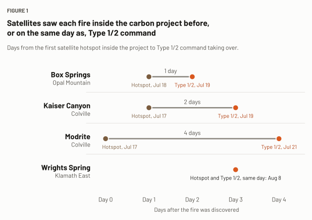
Table 3. Four fires: key dates inside the project
| Fire / Project | Discovered | First hotspot in project (VIIRS) | Type 3 command | Type 1/2 command | CarbonPlan first listed | Burned inside the project |
|---|---|---|---|---|---|---|
| Box Springs / Opal Mountain | Jul 17 | Jul 18 | None (Type 4, Jul 18) | Jul 19 | Jul 19 | 12,172 ac (86.4%), merged with Crosswhite |
| Kaiser Canyon / Colville | Jul 16 | Jul 17 | Jul 17 | Jul 19 | Jul 18 | 32,788 ac (7.2%) |
| Modrite / Colville | Jul 17 | Jul 17 | Jul 18 | Jul 21 | Jul 18 | 25,554 ac (5.6%) |
| Wrights Spring / Klamath East | Aug 5 | Aug 8 | Aug 6 | Aug 8 | Aug 9 | 6,218 ac (1.5%) |
On all four fires, the first hotspot inside the project came on or before the day each reached Type 1/2 command. Wrights Spring is a tie: both came on Aug 8. Three of the four, Kaiser Canyon, Modrite and Wrights Spring, were under Type 3 command first, 2 to 3 days before Type 1/2 command: Kaiser Canyon on Jul 17, Modrite on Jul 18 and Wrights Spring on Aug 6. Box Springs went from a Type 4 incident commander to Type 1/2 command. Only at Wrights Spring did Type 3 command come before the first hotspot inside the project; satellites show where a fire is burning, and the command level depends on the agencies' judgment of how complex the incident is, which section 4 covers.
4 · Does command level predict a fire's impact?
Our hypothesis: fires start small, command moves up as the agencies judge a fire more complex, and if that judgment comes before a fire grows into a carbon project, command level could be a leading indicator for carbon projects assessing fire risk.
Satellites show where a fire is burning; command level reveals how complex the fire is likely to be. Complexity includes assessing impact and resource needs, among many other factors.
Of 351 fires that reached Type 3 command this season, 76 later came under Type 1/2 command, about 1 in 4.6. For those 76 fires, the median time from Type 3 command taking over to a Type 1/2 team taking command was 2.5 days.¹
Among the seven fires that burned into carbon projects in 2026 and reached Type 1/2 command, a Type 3 command preceded the first satellite hotspot within the project for two incidents: Wrights Spring (1.5% of Klamath East) and Chub, a Minnesota fire (0.1% of the Meriwether project). On the other five fires, satellites saw the fire inside the project first, or the fire was never under Type 3 command.
The hypothesis also assumes fires judged more complex grow larger. We sorted the 677 fires in our command record, discovered on or after Jul 1, 2026, by the highest command level each reached and took incident size from the federal incident feed. The table counts fires discovered on or after Jul 1, 2026, so it includes fires that started two days before our hourly record began on Jul 3.
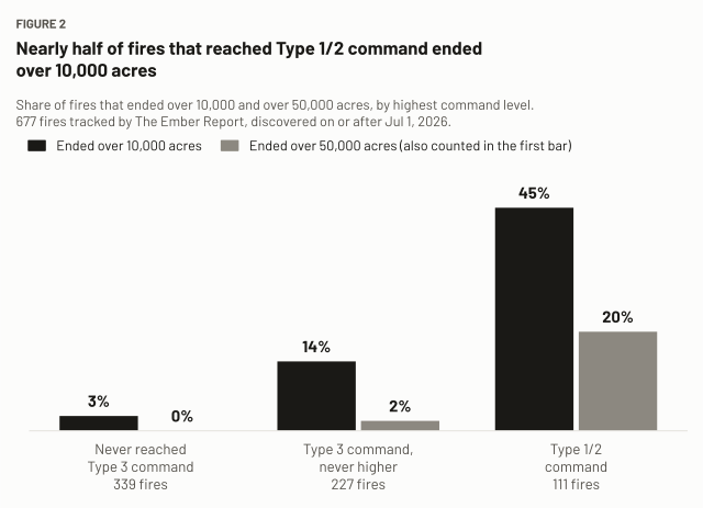
Table 4. Final size by highest command level
| Highest command level | Fires | Size when that level took command (median)² | Final size (median) | Final size (90th percentile) | Ended over 10,000 ac | Ended over 50,000 ac |
|---|---|---|---|---|---|---|
| Never reached Type 3 | 339 | n/a | 434 ac | 2,885 ac | 3% | 0% |
| Type 3, never higher | 227 | 723 ac | 1,326 ac | 13,631 ac | 14% | 2% |
| Type 1/2 command | 111 | 3,225 ac | 7,404 ac | 94,003 ac | 45% | 20% |
The open question is whether command level helps predict a fire's growth and its impact on a carbon project, beyond what a fire modeler already has: current size, satellite growth over the last day, weather, fuel dryness, and distance to the project. Answering it requires an hour-by-hour test that, at each hour, uses only what was known then, trained on one season and tested on another. We have not run that test yet. A daily version, limited to Type 1/2 command, could run on earlier seasons from NIFC's daily situation reports; the hourly version needs the 2027 season.
Notes
¹ The 351 fires that reached Type 3 and the 135 that reached Type 1/2 command cover the whole season, including fires the table leaves out: those discovered before Jul 1 or without a reported size. A NIFC situation report gives a date and no time, and it is current as of 7:30 am Mountain time on that date, so we time its entries at 7:30 am. A team the report lists may have taken command the evening before.
² Size when that command level took command is the last size the federal incident feed reported, as we recorded it, up to 12 hours after our first entry showing the fire at its highest command level, timed as in footnote 1. It is not the size at the hour that level took command. The level is Type 1/2 command for the Type 1/2 row, Type 3 command for the Type 3 row. Fires that reached neither read n/a.
5 · Limits
- The nine carbon projects impacted by fires in our command record are all California compliance projects. Of the 47 voluntary-market projects in a published 2025 map set, one was impacted by a 5-acre fire outside our command record that never had a team.
- No 2026 reversal has been quantified yet. Until one is, we can't tie command timing to credits lost.
- Project boundaries are dated 2024. Carbon projects listed since then are missing.
- Final size is the largest size reported. A few fires are still open and may still grow.
6 · Three questions for you
The Ember Report built this hourly command record and plans to offer access to it as a paid data service. Before formalizing this service, we are trying to learn whether and how people in your field would use it.
- When a fire near one of your projects moves from Type 3 command to Type 1/2 command, what would you want to know, and how soon?
- Would knowing a fire's command level as it changes help your work? If so, in what ways?
- What would the command record need to show before you'd trust it?
If you can spare 20 minutes for feedback, we would be grateful. Write to hello@ember.report.
Terms used in this paper
- California compliance project. A forest carbon offset project in the offset program of California's cap-and-invest program (called cap-and-trade until 2025), run by the California Air Resources Board; 162 of the 209 carbon projects we mapped are California compliance projects, and the other 47 are voluntary-market projects.
- Carbon project. A forest carbon offset project; we mapped 209 from a map set published in 2025, with boundaries dated 2024.
- CarbonPlan's fire monitor. A public fire monitor, run by the nonprofit CarbonPlan, that lists the fires burning inside each forest project in California's compliance offset program.
- Command fact. An entry we record about a fire's command, with its source and the time we recorded it: a team ordered to the fire, a team mobilizing, a team or incident commander taking command, or a command ending.
- Command level. The rating fire agencies give the command on each fire.
- Command record. Our record of each fire's command level, recorded every hour since Jul 3, 2026; every command fact goes into it.
- Complex Incident Management Team (CIMT). An interagency team that runs Type 1/2 command; some CIMTs are sponsored by a state, such as the Oregon Department of Forestry's teams.
- Federal incident feed. The public list of fires published by NIFC, which shows only each fire's current command level.
- InciWeb. The interagency incident information website.
- National incident management team roster. The roster that lists which team is assigned to which fire.
- NIFC. The National Interagency Fire Center, which publishes the federal incident feed.
- NIFC Incident Management Situation Report. NIFC's daily report naming the Type 1/2 teams on large fires, by day; NIFC keeps the past reports in an archive.
- Took command. A fire reaches a command level on the first day a source shows a team or incident commander at that level actually in command of the fire; a team ordered or mobilizing has not yet taken command (section 2).
- Type 1/2 command. Type 1 and Type 2 grouped as one level, run by a CIMT.
- Type 3 command. Command run by a Type 3 team or a single incident commander; we count both as Type 3 command.
- Type 5 to Type 1. The command levels, from Type 5, the lowest, to Type 1, the highest; lower numbers mean more complex fires.
- VIIRS hotspot. A satellite fire detection from the VIIRS instrument (Visible Infrared Imaging Radiometer Suite) on NASA and NOAA satellites.
Sources and credits
- Boundary data. Karnik, Kilbride, Goodbody, Ross, Ayrey, "An open-access database of nature-based carbon offset project boundaries," Scientific Data 12 (2025): https://doi.org/10.1038/s41597-025-04868-2. Data on Zenodo, CC-BY-4.0: https://zenodo.org/records/11459391. California compliance boundaries from CarbonPlan's public mirror: https://carbonplan-forest-offsets.s3.amazonaws.com/carb-geometries/simplified/
- Fire, command and satellite data. The federal incident feed published by the National Interagency Fire Center, the federal perimeter record, the national incident management team roster, the NIFC Incident Management Situation Report, InciWeb and satellite fire detections from VIIRS (NASA FIRMS), as recorded by The Ember Report. Current command labels in the federal incident feed were recorded on Oct 28, 2026.
- ICS-209-PLUS. St. Denis et al., an all-hazards dataset of ICS-209 incident reports, Scientific Data (2020): https://doi.org/10.1038/s41597-020-0403-0. The 2020 paper covers 1999–2014. St. Denis et al., Scientific Data 10 (2023), extends it to 2020: https://doi.org/10.1038/s41597-023-01955-0.
- Situation report dataset. Nguyen, Belval, Wei, Short and Calkin (Forest Service Rocky Mountain Research Station and Colorado State University), "Dataset of United States Incident Management Situation Reports from 2007 to 2021," Scientific Data 11, 23 (2024), CC-BY-4.0: https://doi.org/10.1038/s41597-023-02876-8. It gives daily fire size, personnel and cost for each fire and counts teams only nationally and by geographic area; it does not name the team on each fire.
- CarbonPlan. CarbonPlan, on this season's Pacific Northwest fires (Jul 23, 2026): https://carbonplan.org/blog/pnw-wildfires-2026. CarbonPlan's public fire monitor, daily project files through Sep 20, 2026.
- Registry status, read Oct 28, 2026. ACR projects on ICE GreenTrace, ACR's registry since June 2026: https://greentrace.ice.com/acr/projects. Climate Action Reserve projects on the Reserve's registry: https://thereserve2.apx.com.
- Box Springs merging into the Crosswhite fire. KTVZ (Jul 28, 2026). KTVZ called it the Crosswhite West Fire; the federal perimeter is filed under Crosswhite.
Appendix A · Carbon projects impacted by 2026 fires
We compared every published 2026 fire perimeter with the boundaries of the 209 carbon projects described in section 3. Fourteen projects were impacted, totaling 80,296 acres. Nine of the 14 projects were impacted by fires in our command record (Table A1); the other five were impacted by small fires outside our dataset (Table A2), the largest of which burned 134 acres inside a project.
Both tables are sorted by acres burned, largest first. The acres beside each fire are the acres burned inside that project. In Table A1, the command level in parentheses is the highest level at which a team or incident commander commanded the fire, per the rule in section 2. We read registry status and credits issued on Oct 28; we did not check the registry for the five projects impacted by fires outside our command record, and for the two Climate Action Reserve projects we read the status but not the credits.
Table A1. Carbon projects impacted by fires in our command record
| Project | Registry ID | Project acres | Acres burned (share) | Fires (acres) | Registry status, Oct 28 · credits issued |
|---|---|---|---|---|---|
| Colville | ACR255 | 454,036 | 58,465 (12.9%) | Kaiser Canyon 32,788 (Type 1/2 command) · Modrite 25,554 (Type 1/2 command) · Kartar Creek II 47 (never under Type 3 command) · Kartar 20 (never under Type 3 command) · 10 small fires not in our command record, 56 | Active · 15,161,521 |
| Opal Mountain | ACR554 | 14,093 | 12,172 (86.4%) | Box Springs, merged with Crosswhite, 12,172 (Type 1/2 command) | Active; no termination filed · 590,684 |
| Klamath East | ACR273 | 402,290 | 6,223 (1.5%) | Wrights Spring 6,218 (Type 1/2 command) · Picture Rock 5 (Type 3 command) | Terminated, March 2024; land re-listed as ACR1025–ACR1028, not in our 2024 boundaries · 1,149,657 |
| Spokane Tribe | CAR1314 | 95,341 | 1,867 (2.0%) | Mitre Rock 1,867 (Type 1/2 command) | Registered · not checked |
| Eddie Ranch | CAR1174 | 4,062 | 527 (13.0%) | Lucas 527 (Type 3 command) | Registered · not checked |
| Wilderness Lakes | ACR393 | 5,659 | 483 (8.5%) | Craig Lake 1, 483 (Type 3 command) | Active · 174,007 |
| Meriwether | ACR416 | 167,061 | 204 (0.1%) | Chub 194 (Type 1/2 command) · 3 small fires not in our command record, 10 | Active · 3,942,011 |
| White Mountain II | ACR303 | 122,631 | 181 (0.1%) | Paddy Creek 181 (never under Type 3 command) | Active · 6,932,211 |
| BJT | ACR287 | 7,359 | 15 (0.2%) | Hwy 82, 15 (Type 1/2 command) | Active · 700,067 |
Table A2. Carbon projects impacted only by fires outside our command record
| Registry ID | Project acres | Acres burned (share) | Fire |
|---|---|---|---|
| CAR1183 | 229,248 | 134 (0.1%) | SAGO |
| CAR973 | 228,652 | 16 (0.0%) | Camp 4 Grade |
| ACR549 | 12,731 | 5 (0.0%) | Tower |
| VCS1367 (Pothole Springs) | 28,014 | 5 (0.0%) | Pothole Springs fire |
| ACR741 | 73,083 | <1 (0.0%) | Murr Creek |
Appendix B · Box Springs command history, Jul 17 – Sep 25, 2026
Box Springs burned into the Opal Mountain carbon project. With the Crosswhite fire, it burned 12,172 of the project's 14,093 acres (86.4%); before the two merged, CarbonPlan's monitor showed 50.3% of the project burned under Box Springs alone. Box Springs merged into the Crosswhite fire on Jul 24, and Crosswhite is one fire in the Rowe Creek Complex, so from that day on, Box Springs was under the complex command. The table shows each command level and the team in command, from discovery until the command level dropped on Sep 25.
| Date (Mountain) | Command level | Team in command | Source |
|---|---|---|---|
| Jul 17, 4:00 pm | Discovered; no command level yet | — | Federal incident feed |
| Jul 18, 4:25 pm | Type 4 command | An incident commander | Federal incident feed |
| Jul 19, 6:45 pm | Type 1/2 command | Not yet named | Federal incident feed |
| Jul 19, 10:06 pm | Type 1/2 command | ODF Team 3 (Oregon Department of Forestry) | InciWeb |
| Jul 24, 10:39 am | Box Springs merges into the Crosswhite fire, part of the Rowe Creek Complex³ | — | InciWeb |
| Jul 29 – Aug 3 | Type 1/2 command | ODF Team 3 | NIFC situation reports |
| Aug 3 – Aug 16 | Type 1/2 command | SW Team 2 | NIFC situation reports |
| Aug 16 – Aug 28 | Type 1/2 command | ODF Team 2 | NIFC situation reports |
| Aug 29 – Sep 9 | Type 1/2 command | CA Team 4 | NIFC situation reports |
| Sep 10 – Sep 25 | Type 1/2 command | ODF Team 1 | NIFC situation reports |
| Sep 25, 4:58 pm | Type 4 command | An incident commander | Federal incident feed |
We read the federal incident feed every hour. Its change to Type 1/2 command at 6:45 pm on Jul 19 was in our command record at 7:01 pm, and InciWeb named the team at 10:06 pm. After the merge, team changes come from NIFC's daily situation reports, which give a date and no time.
³ From Jul 16 to the last snapshot in our command record, Oct 2, the federal incident feed showed Crosswhite at Type 3 command on every reading, while Type 1/2 teams in turn managed it. The teams were filed on the Rowe Creek Complex, not on Crosswhite, so the feed's label for the fire never showed them.